
Bicycling. — Broad, hard streets, good pavements in the business center, a continually increasing mileage of bicycle paths, together with the absence of great elevations and steep gradients, make Minneapolis the ideal place for the bicyclist. To these advantages should be added the fact that the city is charming and in the country around are some of the most beautiful and picturesque regions in the Northwest. Wheeling is growing in popularity every year. Probably 50,000 wheels are in use in the city and each year adds to the number.
Bicycle Paths. — There are some fifty miles of bicycle paths in the city and perhaps as much more out side the limits and connecting with city paths. Some of these paths have been built under the direction of the city engineer and some by the park board. All have been promoted by wheelmen. Under city ordinance now in force every wheel using a city path must carry a license tag which may be obtained from the city clerk on payment of a fee of 50c The fund thus created is used wholly in path construction. Strangers should sup ply themselves with tags and save possible annoyance. If a wheel be rented it is the dealers duty to see that it bears a tag. In enforcing the cycle tag law due courtesy will be ex tended to wheelmen from other regions where similar laws are in force — their tags will be recognized as “good” on the Minneapolis paths.

In constructing new paths the city authorities now act in conjunction with the Committee of Associated Wheelmen, composed of representatives of interested organizations, and of which Chas. H. Vanderhoof (of Phoenix Bldg.) is chairman. There are numerous private clubs.
Many of the city paths have been built to connect good paved streets or to join paved streets to others which are ordinarily in fair condition. Some of the paths along the parkway system are simply for the purpose of avoiding steep hills or crowded portions of the driveways.
In the accompanying map no attempt has been made to distinguish between paths, boulevards and paved streets. The routes laid out show where pave ment, path or good road bed assures the cyclist good wheeling at any time except the worst of weather.
The St. Paul system of cycle paths is excellent and is connected with the Minneapolis system at several points. In some parts of St. Paul riding upon the sidewalks is al lowed but the stranger should be sure of his ground before indulging in this amusement, which is strictly prohibited in Minneapolis except iu one remote district.
Bicycle Runs. — Every cyclist likes to vary his route and seek out new ways of going and coming but for strangers the following suggestions are made. In every case the distance is for the round trip from the center . of the city over the shortest good road. Each suggested run is capable of infinite variation to suit the rider as he becomes acquainted with the country. For out of town runs only destinations are mentioned. Riders should use good state and county maps when making these longer excursions.
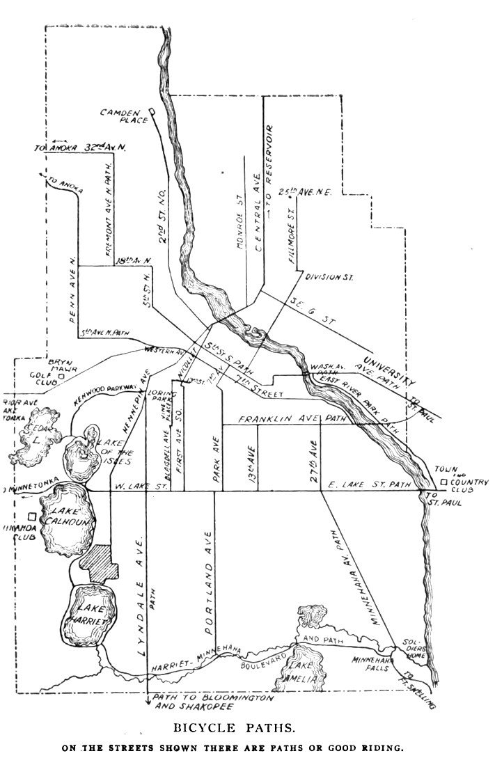
1. — A Half-Hour in Town.— Out 7th St. to 7th Av. S., to Park A v., to Lake St., to Portland Av., to 7th St., to Nicollet Av. 5 miles.
2. — Lake Harriet. — Hennepin Av. to Kenwood parkway, to Lake of Isles boulevard, to Calhoun parkway, to Interlachen park, to Lake Harriet. About 10 miles. Return may be va ried by riding east from Lake Harriet to Lyndale Av., or from Lake Cal houn to Hennepin Av. and entering city over either of these avenue. 10 miles.
3.— Minnehaha.— Out 7th St., to Park, to Lake, to Minnehaha Av., to
Minnehaha Park and Falls. 16 miles.
4. — Minnehaha-Harrlet. — Henne pin and the parkways to Lake Harriet as in No. 2. At southeast point of Lake Harriet take Minnehaha parkway, follow to the park, return over route 3. 23 miles.
5. — Fort Snelling. — Same as route 3 but following path 1% miles be yond Minnehaha to Fort Snelling, a most picturesque place. 20 miles.
6.— Fort Snelling and Cleveland Av.— Same as route 5 but instead of returning over same route cross bridge at the fort and follow Cleve land Av path to Lake St. bridge, oross bridge and go west on Lake to Park Av. 20 miles.
7.— University.— S. 5th St. to 10th Av. S., on 10th Av. S., across bridge to University Av., on University to Campus, through campus to Washing ton Av., returning via Washington Av. bridge, 3rd and 5th Sts. 5 miles.
8. — East River Bank. — 5th St. to 15th Av. S., to Washington, to bridge, to East River Bank parkway, which follow to government dam and Lake St. bridge, returning as In route 6. This may be shortened by recrossing the river at Franklin Av. bridge and following Franklin and Park into the center. Or It may be extended to Fort Snelling over the Cleveland Av. path.

9.— St. Paul.— 7th St., Park Av., Lake St., across bridge to Summit Av. path, to St. Paul. 24 miles. St. Paul may be also reached via University Av., or via Fort Snelling, taking the W. 7th St. path into St. Paul af ter crossing the bridge at the fort. The latter route is 17 miles one way ; If return is via Summit Av.„ the run is nearly 30 miles.
10. — Como Park. — Lake St. and Summit Av. to Lexington Av., to Co mo. 24 miles. Como is St. Paul’s leading park.
11. — Minnetonka. — Hennepin Av. .to Lake to Calhoun, taking Minneton ka path at northwest corner of Cal houn. This path follows Lake St. boulevard to Hotel St. Louis, at Minnetonka. 32 miles. This run may be extended by diverging to the left before reaching Hotel St. Louis and passing around “lower lake” through Excelsior and Wayzata. 48 miles. Use good road map.
12. — Bloomington. — Out Hennepin to Lyndale, Lyndale to limits, follow path to village of Bloomington. 26 miles.
I5. — Shakopee. — Same as 12, but follow Shakopee path beyond Bloom ington. 50 miles.
14. — Northfleld. — Through St. Paul and Farmington. 104 miles.
15. — Osseo and Anoka. — 6th St. N. to 18th Av. N., to Penn Av., to new Crystal Lake path, to Osseo and Anoka. 40 miles.
16. — White Bear Lake. — Any route to St. Paul or Como, and path to White Bear. 50 miles.
17. — Stillwater. — Any path to St. Paul, E. 7th St., and Lake Elmo path to Stillwater. 64 miles.
-Hudson’s dictionary of Minneapolis and vicinity, 1902
